Where Is Yosemite?

Driving Directions From Major Cities And Nearby Airports

So...where IS Yosemite?
Encompassing 1189 square miles of the Central Sierra Nevada Mountains, the boundary of Yosemite National Park ranges from the Western foothills and an elevation of 2,000 feet to the eastern mountain crest at over 13,000.
Within Yosemite National Park you will find three distinct areas of interest; the High Sierra, the Giant Sequoia Groves, and Yosemite Valley.
Getting to Yosemite has become much easier over the years,with most major cities in both California and Nevada within a 9 hour drive of the Park.

By contrast...“In the 1870’s a Yosemite-bound traveler would take a river steamer to Stockton, then a stagecoach or mud wagon over terrible roads. One 1870’s visitor said that the fence six feet from the stagecoach was invisible behind the dust cloud. Finally a horseback ride led the travelers down steep trails into the valley.” (from the Yosemite Pocket Guide).

Entrances to the Park
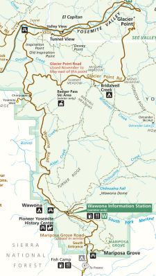
Yosemite may be accessed via four different Park entrance stations:
1. Highway 41 North from Fresno enters the Park along the Old Wawona Stagecoach route at the South entrance.
2. Highway 140 West from Merced enters at the Arch Rock entrance.
3. Highway 120 West from Modesto and Manteca enters at the Big Oak Flat entrance.
4. Highway 120 East from Lee Vining and Highway 395 enter through the Tioga Pass entrance.
Driving Times...

Driving times to the floor of Yosemite Valley vary depending on the season that you choose to visit and the associated weather conditions.
The following are travel times and distances from a number of popular points of origin:
Where Is Yosemite from Lake Tahoe:
Lake Tahoe via the Tioga Road-4.5 hours-198 miles
Lake Tahoe via Sacramento Hwy.140-5.75hours-265 miles
Lake Tahoe via Hwys.120 and 49-5.25 hours-200 miles
To Yosemite from Las Vegas:
Las Vegas via Tioga Road and Hwy.95-8 hours-399 miles
Las Vegas via Bakersfield and Hwy.15-8.5 hours-475 miles
To Yosemite from Los Angeles:
Los Angeles via Hwy. 41-6 hours-313 miles
Los Angeles via Hwy. 140-6.25 hours-276 miles
Los Angeles via Tioga Road -8 hours-410 miles
To Yosemite from Monterey:
Monterey via Hwy. 140-4.5 hours-204 miles
To Yosemite from Sacramento:
Sacramento via Hwy. 120 to Big Oak Flat -4 hours-160 miles
Sacramento via Hwy. 140-4 hours-195 miles
To Yosemite from San Francisco:
San Francisco via Hwy. 120 to Big Oak Flat -4 hours-195 miles
San Francisco via Hwy. 140-4 hours-211 miles
To Yosemite from San Diego:
San Diego via Hwy. 41-8 hours-441 miles
San Diego via Hwy. 140-8.25 hours-484 miles
Directions to Yosemite from the nearest major Airports:
Where is Yosemite from the Fresno Yosemite International Airport? (FAT)
Drive north on 41 to Yosemite. The driving time will be about 1.5 hours to the park’s South entrance through Wawona and then another hour to Yosemite Valley.
Where is Yosemite from the Modesto City-County Airport? (MOD)
Drive east on 120 to Yosemite or as an alternative drive south on 99 to Merced and take 140 to Yosemite. The driving time will be about 1.5 hours to either the Big Oak Flat or Arch Rock park entrances, and another half an hour to Yosemite Valley.
Where is Yosemite from the San Francisco and Oakland International Airports?
San Francisco International (SFO):
Take 580 east to 205 east and then 120 East to Yosemite. An alternative is to 99 south to Merced and 140 into Yosemite. Allow about four hours to the Big Oak Flat or Arch Rock park entrances and about another half hour to Yosemite Valley.
Oakland International (OAK):
Take 580 east to 205 east and then 120 east to Yosemite. An alternative is to 99 south to Merced and 140 into Yosemite. Allow about four hours to the Big Oak Flat or Arch Rock park entrances and another half hour to Yosemite Valley.
The Yosemite Lodge

Yosemite is open every day of the year, 24 hours each day, and a park entrance fee applies to all visitors. If you drive your private car, minivan, pickup truck, or RV, the entrance fee is $25 per car. This is good for seven days and is valid for unlimited entries into the park.
To return to the home page from where is yosemite please click here.

Yosemite...What To See Once You Get There- And Other Fun Stuff
Yosemite's Scenic Wonders

Suggestions For Touring Yosemite Valley
Bill Berry's Prints Return

The Story Of Fishing Yosemite

Yosemite's Majestic Waterfalls

Yosemite's Majestic Waterfalls
Camp Fish And Hike The Yosemite High Country!

The Crown Jewels Of Yosemite National Park.
Yosemite Camping And Hiking In Wawona

Yosemite Camping And Hiking In Wawona
Visit Yosemite's Big Trees

Yosemite's Mariposa Grove In Wawona
Yosemite's High Country From Your Car

Yosemite's High Country From Your Car


