The Yosemite High Sierra Camps,
The Crown Jewels Of The Yosemite High Country...
Come Camp, Hike And Fish!

Six of the seven Yosemite High Sierra Camps comprise the High Sierra Loop Trail. The "loop"makes up a circuit of roughly sixty miles in length with the various camps located along it at intervals of about nine miles. Yosemite's High Sierra Camps were selected not only because of their scenic beauty, but for their proximity to other surrounding points of interest like lakes and streams for the fisherman. Hikers with no interest in fishing will not be disappointed either since the "loop" runs through some of the most stunning scenery to be found anywhere in Yosemite National Parks more than 1,100 square miles of wilderness territory.

Yosemite High Sierra Camp: May Lake
Elevation: 9,270 feet. 9.8 miles from Yosemite Valley and 8.6 miles from Glen Aulin Camp. 8 miles from Sunrise Camp.
Since "sturdier” May Lake bound back packers usually start their hikes from Yosemite Valley as do the six day saddle trips. Therefore this description begins from there.
The trail to May Lake Camp leaves Yosemite Valley at Mirror Lake and climbs up and out of Tenaya Canyon by way of the “Tenaya zigzags”. The hike is nearly all uphill since May Lake lies a mile higher in elevation than the valley floor. The trail crosses the Tioga Road near Snow Flat, which got its name from the heavy snowpack which piles up there during the winter months. A mile beyond at the foot of Mount Hoffman lays May Lake. On its eastern shore in a beautiful setting of mountain hemlocks is the May Lake Camp itself.
Just beneath the northern wall of Mount Hoffman at an elevation of 10,921 feet is the horseshoe-shaped head of Yosemite Creek, with its numerous little glacier-scooped lakelets. It is this water and the surrounding deep snow banks that form the main source of Yosemite Creek. It is miles back down below this location that Yosemite Creek plunges over the wall of the valley at an elevation of 6,525 feet and becomes Yosemite Falls.
A promontory behind May Lake Camp provides one of the most spectacular panoramas in the whole of the Sierra…a full visual sweep of Tenaya Canyon from Half Dome at its foot to Tenaya Lake at its head, with Cathedral Peak boldly outlined in the distance against the horizon.
Fishing At May Lake

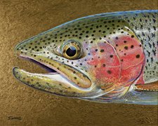
May Lake contains beautiful eastern brook trout, and the best fishing there occurs late in the season.
Tenaya Lake is a 4 mile hike from May Lake and is the largest in the Yosemite High Sierra. It is on the shores of Tenaya Lake that the last of the Yosemite Indians were captured by the Mariposa Battalion.
While Tenaya Lake is said to have large fish in it, they are
difficult to catch because of the sheer size of the lake and the depth of the
water. Spin casting from the eastern shore is probably your best bet since
there is a broad sandy beach which is also popular with campers and the very
bravest of swimmers. The water temperature is bone chilling!
Side Trips From May Lake...For The Experienced Hiker
Mount Hoffman and Tenaya peak are both amazing side trips for those with climbing experience. During years of normal winter snows in the Sierra, the northern slope of Mount Hoffman offers good skiing all of the way into July. From the summit of Mount Hoffman, one has a superb view of the park since the mountain towers above the center of Yosemite and is higher than any of the nearby peaks. In midsummer, over 100 varieties of wildflowers blossom on Mount Hoffman and neighboring slopes.
John Muir said of Mount Hoffman, “On no other Yosemite Park Mountain are you more likely to linger."
Nearby, Tenaya peak overlooks Tenaya Lake and rises above the water to an elevation of 10,300 feet.
Yosemite High Sierra Camp: Glen Aulin
Elevation: 7,800 feet. 8.6 miles from May Lake and 7.6 miles from Tuolumne Meadows Lodge.
Following the McGee Lake Trail across a number of high ridges, one eventually drops down into Glen Aulin, the most restful of all of the campsites. Here the ancient Tuolumne Glacier, which reached its maximum length at over 60 miles, excavated a small lake basin which has filled with vegetation over the many years since. Below the camp the Tuolumne River meanders for more than a mile through this basin. It winds on quietly through forests of aspen and lodge-pole pine, reflecting the canyon walls in the fresh green of cool, flower-bordered pools.
Glen Aulin Camp lies at the foot of the White Cascade on the Tuolumne River, in the outer fringes of one of the finest Sierran stands of mountain hemlock. The cones of the mountain hemlock are very small and the graceful branches bend downward to where they cover the trunk almost entirely.
You will probably notice the deep vertical scratches in the smooth white bark of the aspen that stand below the camp. These are “territorial” bear claw marks. Naturalists believe that the bear gouging the highest scratches in the trees successfully marks his claim to that area.
Don’t Miss The Breathtaking Upside Down Waterwheel, California And Le Conte Falls
Perhaps the most remarkable of all of the Glen Aulin scenes is the series of falls made by the Tuolumne River in its spectacular drop down to the Grand Canyon of the Tuolumne.
The California Falls, Le Conte Falls and the better known Waterwheel Falls are literally upside down waterfalls. Here ridges and depressions in the riverbed toss the turbulent white water in magnificent arcs 30 to 40 feet high during the height of the flow. To be certain that you see the finest of these waterwheels follow the river to Return Creek Junction. Fishermen will do this anyway.
Fishing At Glen Aulin

Some of the best stream fishing in the Sierra is to be found in the Tuolumne River near Return Creek. The many beautiful pools offer exciting opportunities to catch good-sized rainbow and brown trout.
One of the favorite fishing trips from Glen Aulin is to Virginia Canyon 8.1 miles away, where Return Creek is not the turbulent difficult stream that it is lower down and features small but “game” rainbow trout.
Those wanting lake fishing with Glen Aulin as a base will find it at McCabe Lakes, where the fish can range from 8 inches to 18 inches. The lakes are found off-trail 2 to 3 miles up the East Fork of Return Creek, which joins the main fork of that stream where the Virginia Pass and Cold Canyon trails meet. The East Fork branches 1.5 miles upstream and the southerly branch drains the three lakes. Much of this route is on a fisherman's trail and the 10 miles covered-(one way), represents a long and tiring day. The long hike will be well worth it to the dedicated fisherman though!
Side Trips From Glen Aulin…For The Experienced Hikers
Muir Gorge - (9.9 miles), is a narrow and deep box canyon through which the Tuolumne River flows. The canyon contains a small waterfall and a “bottomless” pool, the bottom of which cannot be seen even during the lowest water. John Muir was the first recorded white man to pass through the Gorge. Only strong swimmers have done so since, during the late season and in drier years.
The trail climbs several hundred feet above the river at this point and continues to Pate Valley and Hardin Lake near the Tioga Road…a distance of 22 miles. The Tuolumne Canyon provides a worthwhile trip for those with no interest in fishing as well. The falls and cascades that dash down the canyon sides are truly awe inspiring. Steep walls tower above the canyon bottom, upon which there is room for the river and a trail…and nothing more.
Yosemite High Sierra Camp: Tuolumne Meadows

Elevation: 8,600 feet. 7.6 miles from Glen Aulin Camp and 7.2 miles from Vogelsang Camp by way of Rafferty Creek. 12.3 miles from Vogelsang Camp following Ireland Creek. 11 miles from Sunrise Camp.
The trail from Glen Aulin to Tuolumne Meadows follows the Tuolumne River past White Cascade and Tuolumne Falls, and then onward to Soda Springs where you can drink natural soda water from its source in the ground. Across the Tioga Road from the springs stands the Tuolumne Meadows Lodge.
The Lodge is located on the Dana Fork just below Dana Cascade, and is the largest of the six High Sierra Camps.
The Meadows of the Dana and Lyell Forks of the Tuolumne River are the most extensive of High Sierra grasslands. From this favorite region of John Muir’s, the trail bearing his name winds its magnificent way. Heading southeast along the Sierra Crest for 188 miles, the Muir Trail reaches an elevation of 14,495 feet at Mount Whitney. Mount Whitney is second in height only to Mount McKinley; the highest peak in the United States.
Here the Tioga road passes through Tuolumne Meadows. The road then climbs to the Tioga Pass before it drops 3,500 feet to the Eastern Desert, and alkaline Mono Lake.
Just east of Tuolumne Meadows loom two huge reddish mountains named Dana and Gibbs; and to the geologist these peaks are of special significance. Now comprised of metamorphic rock, they both have transformed over time from their original sedimentary and volcanic composition. Mount Dana and Gibbs represent the remnants of the ancient sierran landscape that once covered the entire region. Originally thousands of feet in depth, most all of the metamorphic material has now eroded away. With this surface erosion the harder granite which in its molten state had welled up beneath, has now been exposed.
Fishing At Tuolumne Meadows
The Lyle and the Dana Forks of the Tuolumne River provide the best stream fishing around Tuolumne with brown, eastern brook, and rainbow trout. As might be expected, as one follows the Tuolumne River downstream and away from where the other fishermen are, the trout become larger.
There are five lakes that are easy one day hiking trips from Tuolumne including Dog, Gaylor, Young, Elizabeth and Cathedral Lakes. Adjacent to the road and just outside the Yosemite park boundary are Tioga, Ellery and Saddlebag lakes all of which have nice trout.

The trout caught within Yosemite National Park are all wild trout, and are the result of natural reproduction after planting in the early years. There are so many good places to fish that one could remain in Tuolumne Meadows itself for two weeks, fishing different lakes and streams every day.
Side Trips From Tuolumne Meadows…For Experienced Hikers
If you climb no other peak during your High Sierra trip, you must experience the striking scenery from the top of Mount Dana. From here you can begin to grasp the tremendous extent of the Sierra Crest. The desert range recedes into the eastern haze, and to the west are the foothills and then the coastal range. Mono Lake is 6,627 feet beneath the summit.
It is a long but easy climb of 3 miles, gaining 3,100 feet in altitude from the start of the journey at Tioga Pass. Mount Dana eventually reaches an elevation 13,050 feet and is the third highest peak in the park.
From Tioga Pass the Dana Glacier is 3 miles off-trail along the stream that flows into Tioga Lake. Below the glacier itself are several moraines and lakes with the distinctive milky blue hue peculiar to water containing glacial silt.
Should you wish to visit it, the route to the Lyell Glacier is well marked. Horses may be taken up to 10,500 feet on the Lyell Fork Trail where it then turns east and crosses Donahue pass. Be sure to apply lots of suntan lotion before you reach the ice and put on a good pair of dark glasses before venturing out onto it. The summit of Mount Lyell is at an elevation 13,090 feet and is the highest mountain in the Park.
Both Mount Lyell and Mount Maclure may be climbed from the head of the westerly glacier.
This trip usually takes about two days and requires considerable climbing experience.
Yosemite High Sierra Camp: Sunrise

Elevation: 9,400 feet. 11 miles from Tuolumne Meadows. 10 miles from Merced camp, and 8 miles from May Lake camp.
The Sunrise Trail from Tuolumne Meadows leaves the Tioga Road at Budd Creek, about 3 miles west of the Tuolumne Meadows Lodge. For the first mile the trail is quite steep as it twists through forests of lodgepole pines. At about the 3 mile point, the trail to lower Cathedral Lake crosses the Sunrise Trail, and the lake lies about one half mile west. There many marvelous mountain views along the Sunrise Trail as you get nearer to the summit of Cathedral Pass. Among these are Cathedral Peak, Tresidder Peak, the Echo Peaks and Matthes Crest. In the distance from here may be seen the Tower and Matterhorn peaks on the northern boundary of the park.
At the 10,300 foot summit of Cathedral Pass three drainage basins become obvious…into Tenaya to the west, into the Merced River basin to the south, and into the Tuolumne area to the north. The trail then begins a gentle descent toward Long Meadows, passing Columbia Finger on the right. While following the meadow’s edge Sunrise Camp is eventually reached near its end.
Located on a boulder-strewn bench about 30 to 40 feet above the meadow, Sunrise presents an inconspicuous first appearance to the hiker and rider on the trail. From this camp, exciting vistas of Sierra peaks are everywhere. To the south is the Clark Range, to the east are Florence, Vogelsang and Simmons peaks, and to the Northeast is the Matthes Crest.
Fishing At Sunrise Camp
The nearest lake fishing to be found near Sunrise Camp is in the three Sunrise Lakes to the Northwest of it. All of them are easy to reach with the farthest lake being only 2 miles away. Because of their proximity to the camp the lakes are heavily fished but all are good breeding lakes for the eastern brook trout. Mildred Lake is also good for the eastern brook and Echo Creek which lies to the Southeast provides the nearest stream fishing.
Side Trips From Sunrise Camp…For Experienced Hikers

Within 5 miles of Sunrise Camp there are several peaks that present interesting and challenging climbs. Columbia Finger, Tresidder Peak and Echo Peaks are all difficult and should not be undertaken by inexperienced climbers. An easier and very enjoyable hike is the 10 mile round-trip hike to Clouds Rest.
To get to Clouds Rest, take the trail from Sunrise Camp to the Forsythe Trail Junction, then turn left to the south and follow it for about 1.5 miles to the Clouds Rest Trail junction. From here it is only about a mile to the summit. One may return by back-tracking on this route or may continue south along the Forsythe Trail to where it intersects the Sunrise Trail.
Turning left and heading north returns you to camp over Sunrise Mountain. The trail to Merced Lake intersects the Sunrise Trail at roughly the same point as it intersects the Forsyth Trail.
Make sure that you are headed back north to Sunrise Camp and not to Merced Lake by mistake.
Yosemite High Sierra Camp: Vogelsang

Elevation: 10,300 feet. 7.2 miles from Tuolumne Meadows Lodge by way of Rafferty Creek. 12.3 miles via Ireland Creek. 9.1 miles from Merced Lake Camp via Vogelsang Pass and 7.6 miles via the Babcock Lake route.
Vogelsang Camp is located at the timberline where vast panoramas of jagged peaks stretch across the horizon. One is literally “on top of the world” when on the Vogelsang Pass trail, which rises to an elevation of 10,700 feet. The thrilling expanses will become a treasured memory of your journey through Yosemite's fabulous mountains.
The Vogelsang area was once a “gathering place” for glaciers during the Ice Age, and glacial cirque's abound here. This geological feature offers striking evidence of its place as the birthplace of the glaciers. The frail knife-edge like peaks such as Vogelsang itself managed to remain above the highest limits reached by the glacial ice. Other evidence of glaciers is the step formation of the canyons where some now contain lakes where hollows were once excavated by the ice. There are nine steps on the Lewis Creek, and others can be found at Merced Lake, Lost Valley, Little Yosemite and finally in Yosemite Valley itself.
In the timberline forest around Vogelsang Camp grows the white bark pine, the favorite tree for many who return to the High Sierra. With it they often associate their fondest memories of the mountains and of the lake-jeweled meadows. It is upon those neighboring crags and open slopes that this pine alone seems to find sustenance.
Fishing At Vogelsang Camp
Bernice Lake is at an elevation of 10,100 feet is home to the eastern brook trout. Several small lakes above Bernice are also good for fishing smaller trout of the same variety.
The Lewis Fork of the Merced River contains large numbers of small eastern brook trout and is a fabulous place for beginners to fish.
Fletcher Creek contains both small eastern brook as well as golden trout. Nearby the Babcock Lake trail passes through exquisite meadow expanses near Emeric Lake and several lakelets. Check them out.
Emeric lake features good sized rainbow trout, and Booth Lake is one of the best producing lakes in the area with eastern brook. Eveline Lake contains larger eastern brook, but is considered a spotty producer. Ireland Lake has a population of small eastern brook and fishing conditions there are usually good for the less experienced fisherman. Vogelsang Lake can sometimes provide good fishing for nice rainbow trout. Fletcher Lake contains eastern brook, and Townsley Lake has mostly golden trout.
Side Trips From Vogelsang For Experienced Hikers.
From Vogelsang Pass experienced mountaineers may climb Vogelsang Peak for a view as fine as you will find anywhere in the Park. Parsons Peak cirque is southeast of camp at the headwaters of Fletcher Creek.
You will find four lakes above Fletcher Lake, the highest is at 10,500 feet. Above, the precipitous glacier-cut walls of the cirque rise nearly 2,000 feet more to Parsons Peak.
Rafferty Peak is climbed starting from Tuolumne Pass. Precipices drop abruptly from the summit into Echo Creek basin across which you will see some the most difficult Yosemite peaks…Cathedral, Echo and the Cockscomb.
Yosemite High Sierra Camp: Merced Lake

Elevation: 7,150 feet. 9.1 miles from Vogelsang by way of Vogelsang Pass. 7.6 miles from Vogelsang via Babcock Lake. 10 miles from Sunrise Camp. 12.4 miles to Happy Isles in Yosemite Valley
Merced Lake Camp is situated in a friendly wooded valley surrounded by glistening white granite. The temperature is ideal and the camp itself is famous for real mountain comfort and hospitality. Merced Lake is near the camp and is a pleasant swim. Lodgepole and Jeffrey pines, white fir and quaking Aspen prevail. Up on its exposed rocky shelves grow gnarled western junipers.
Forest country is also bird country and you will hear and see many species. Perhaps the most memorable around Merced Lake is the Clark Nutcracker…a relative of the crow. He will be found all around the area enjoying his well earned reputation as the most raucous of all of the sierran birds.
The trail between Merced Lake and Yosemite Valley is undoubtedly one of most spectacular in the park. Skirting the lake, the trail passes through a beautiful grove of aspen, then forests of pine and fir. Next it suddenly emerges onto the most extensive area of glacier polished granite in the northern hemisphere.
It seems unimaginable that over 20,000 years have passed since the Yosemite glacier retreated and exposed this burnished rock. Soon the acres of granite disappear and the trail enters Lost Valley.
The trail then winds through Little Yosemite with its great forests of fir, pine, cedar and patches of multicolored wildflowers. Then onward past Nevada Falls and then Vernal Falls. Downward through the steep walls of the Merced Canyon; Happy Isles is finally reached at the floor of Yosemite Valley.
Fishing At Merced Lake
Merced Lake usually affords good fishing since it is well suited for natural trout reproduction. It contains mostly brown trout and fishing boats are available. Near Merced Lake are many other fishing waters, including Washburn Lake which affords even easier fishing than does Merced Lake for the beginner. The eastern brook trout which it contains usually run a bit smaller.
The trail to Washburn Lake follows the river closely and passes many interesting cascades and water-slides which drop down the canyon walls. In the Lyell Fork above the lake, the trout are small but the fishing is good.
Babcock Lake contains eastern brook and at times the small lake affords excellent fishing. Bernice Lake, Lewis Fork, and Fletcher Creek are all good places to fish with Merced Lake camp as the base.
All along the Merced River from Merced Lake to little Yosemite there is good fly fishing in the beautiful flat pools and riffles.
Side Trips From Merced Lake For Experienced Hikers And Fishermen
For those having climbing and off-trail experience there are many interesting side trips from Merced Lake. Mount Clark is 6 miles away, Gray Peak is about a 7.5 mile hike and Adair Lake is 7 miles away at an elevation of 10,300 feet. Nice Golden Trout are accessible from Gray Peak Fork.
From the Isberg Pass trail, one may penetrate an immense glacial amphitheater at the head of the Lyell Fork where 23 lakelets lie surrounded by the splendid peaks of Lyell, Maclure, Rogers, Electra, Foerster.
To return to the home page from yosemite high sierra camps please click here.
 Subscribe To Our Blog Here


Other High Country Related Pages
Where IS Yosemite?

Driving Directions To Yosemite
Camping In Yosemite's Wilderness

Bill Berry's Prints Return

The Story Of Fishing Yosemite
Yosemite's High Country From Your Car

Drive The Big Oak Flat Road To Tioga Pass
A Brief History Of The Tioga Road

Building The Tioga Road Was A Monumental Task
Camping and Hiking in Wawona

Camp And Hike Along The Old Yosemite Stage Route